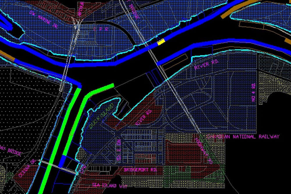
North Fraser Mapping and Harbour Headline Control, Metro Vancouver


Date
1958-2008
Services & Technologies
CAD & Digital Modeling, Cadastral - Legal Land Surveying, Vancouver OfficeAbout This Project
For much of the period from 1958 to 2008, Underhill was the consulting surveyor for the North Fraser Harbour Commission. Underhill was responsible for establishing the harbour headline control network and provided mapping of the North Arm of the Fraser River. The mapping evolved over time with advances in photogrammetry. In 2008, the North Fraser Harbour Commission (then called the Port of North Fraser) was merged with the Vancouver Port Authority and the Fraser Port Authority, to form Port Metro Vancouver.
1958 Harbour Headline Mapping
The harbour headline of the North Arm was originally defined by description. In 1958 a mapping program was undertaken to define the headline in terms of coordinates relative to a monumented framework. A classic triangulation network of the control was made. The mapping of the harbour, compiled from 1958, aerial photography and control surveys by Underhill & Underhill, was completed in 1959. Planimetric detail was scribed from the air photos and this information was combined with an overlay of cadastral survey lines.
Although revisions were made from time to time, the information on the plans became outdated, and the reference monumentation largely destroyed by dyking and new construction. The plans were at a scale of 1″ to 200′.
Harbour headline, channel, and control monument coordinates were at ground level relative to a project-specific imperial datum and expressed in terms of latitudes and departures.
1979 Harbour Headline Mapping
In 1979 the Commission again contracted Underhill to update its mapping. It was decided that a number of improvements should be made to modernize the mapping and make it more appropriate for the Commission’s needs. These included;
Metrification – Canada was rapidly making the transition to the metric system whereby all measurements and units of reckoning were being converted to the International System of Units (SI). The old maps of the North Arm were becoming obsolete because of the change of units and the developments that had taken place since their production 20 years earlier.
Integrated Survey – By 1979 integrated surveys had become a policy implemented by the Surveys Branch of the Province of BC. At the time, areas of Surrey and Delta had been declared as “Integrated Survey Areas” and Richmond was in the process of setting out its monuments. In time, all of the jurisdictions surrounding the North Arm would become integrated. The coordinates used in the system would be NAD’27 UTM defined by existing first- and-second order provincial control (Point Atkinson & Burnaby Mountain). Traversing with EDM (electronic distance measurement) was used to tie the existing 1959 triangulation to geodetic control. EDM distances were used to strengthen the existing triangulation.
The mapping program included
- Update, or replacement of monuments
- Orthophotography, which was used as the base map with cadastral and integrated survey information overlaid (The orthophotography provided for every detail on the original aerial photography to be available rather than only those features chosen to be scribed by planimetric mapping)
The final mapping was produced in 16 sheets at a metric scale of 1:2500.
1989 Harbour Headline Mapping and GIS
In 1989, following an information system consultant’s report which showed that the majority of the Commission’s data was spatially based, they decided that the logical direction to go was towards digital mapping and GIS. The program involved:
-
- Control Update – Destroyed monuments were replaced and resurveyed. A number of old coordinates were changed to reflect observed displacements.
-
- Digital Cadastral Compilation – The former scribed cadastral overlay was recomputed using coordinate geometry (COGO) for all of the Commission’s lease surveys. Surrounding municipal (upland) was compiled from municipal digital data (when available) or digitized from hardcopy maps.
-
- Digital Mapping – Planimetric features were captured by digital photogrammetric means. These included improvements on the foreshore (buildings, wharves, piles, dolphins, etc.), vegetation limits, and high-water mark.
-
- Orthophotography – New orthophotos were made of each of the 1:2,500 map sheets. No cadastral overlay was generated.
- Geographic Information System (GIS) – A GIS was implemented in Terrasoft. The digital cadastral and mapping data formed the graphic side of the system. Parcel attribute information was loaded from BC Assessment Authority data and NFHC leasing information. The system contains over one hundred viewable features. These include:
- NFHC river channel features (such as buoys, pilings, harbour headlines, and channel lines)
- Cadastral features within a 200m buffer of the river banks
- FREMP (Fraser River Estuary Management Program) data and other environmental and shoreline habitat banks
- NFHC leasing information (i.e., water lots, log storage areas, and rights-of-way)
- Planimetric mapping features
- Municipal zoning data
- BC Assessment Authority data
Nine individual themes were developed and linked to external attribute databases for query and analysis purposes. A customized menu system was developed to provide exceptional “user friendliness.” Output capabilities included vector pen plotting and DGN and DXF file formats. Read our paper Boats Dolphins and Log Booms – A Management Tool for Water Related Facilities.
1996 Harbour Headline Control Modernization
In 1996 Underhill undertook to bring the North Arm control system into better agreement with the integrated survey areas which had grown up around it. NFHC was still on NAD’27 and needed to be moved to NAD’83, which the surrounding ISAs had recently moved to. The observations from the 1989 survey, some of those from the original 1959 survey, GPS positions on some of the control points, and ties to surrounding integrated survey monuments were used, in a GeoLab adjustment, to produce NAD’83 coordinates for a framework of NFHC control. These points were used in the generation of a transformation surface. The surface was used to generate a grid of northing and easting shifts. This grid was used in conjunction with in-house software to transform the entire NFHC data set to NAD’83.
2001–2005 GIS Updates
Incremental updates to land base (cadastral fabric) and attribute data were done when needed.
2008 onwards, Port Metro Vancouver
After nearly one hundred and fifty years of existing separately, the Fraser River Port Authority, North Fraser Port Authority and Vancouver Port Authority combined to become the Vancouver Fraser Port Authority (VFPA), now known as Port Metro Vancouver. Underhill continues to provide survey and mapping expertise over all areas of Port Metro Vancouver’s jurisdiction.
NFHC Lease Survey Information for British Columbia Land Surveyors
The NFHC harbour headline control is utilized to define the location of the harbour headline. As this control predated the establishment of virtually all integrated survey areas (ISAs) in the Lower Mainland there are obvious differences and distortions in the control fabric relative to these more recent surveys.
Some time after the Province adopted the NAD’83 datum it was decided to migrate the NFHC data to this datum from its original NAD’27 base. The present system is based on the original survey of 1959 with updates, additions, GPS on selected points, and some ties to surrounding ISAs. Although this resulted in better agreement overall with the surrounding ISAs there are still some local differences (±0.5m). The relative accuracy of the control between monuments is 1:5000 or better, but some monuments have been disturbed from their original locations.
In light of this fact, the present harbour headline control monuments must be employed in establishing the location of the harbour headline for surveys within the jurisdiction of NFHC.
Lease surveys of North Fraser foreshore should be done in accordance with the Surveyor General’s Instructions for Surveys under the Land Act, with the following additions.
Ties will be made to a minimum of two NFHC harbour headline control monuments for the purposes of computing the location of the harbour headline.
Note that the NFHC coordinate system is NAD’83 UTM Zone 10. The definition of the NAD’83 datum in this regard, while consistent overall with the surrounding ISAs, will show localized variations. The relationship between the harbour headline (HH) points and the control points is fixed. Computation of the theoretical intersection of the projection of lease boundaries with the HH should consider this fact.
Generalized procedure in establishing the location of the harbour headline on a NFHC Lease Survey:
- Tie to at least two NFHC control monuments. Confirm that they are in relative agreement.
- Reduce your survey of the upland cadastral framework to grid and compute its position relative to the NFHC control points.
- Project your boundaries to intersect the harbour headline chord, or chords, as defined by HH UTM coordinates.
- Produce the ground distances for the intersections.
- Rotate and shift your survey back onto the appropriate ISA system.
- On your plan insure that
- there are ties between your survey and NFHC control
- harbour headline points are shown (lines can be foreshortened either side of the survey), with bearing and distances between
- a table of NFHC coordinates used is shown (control and harbour headline).